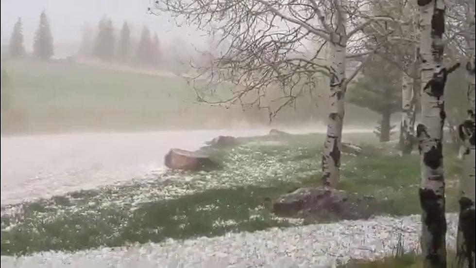
The Cheyenne Office of the National Weather Service says areas of southeast Wyoming and the Nebraska Panhandle could see hail, heavy rain, strong winds, and even an isolated tornado this afternoon and evening.

The agency posted the following on its website:

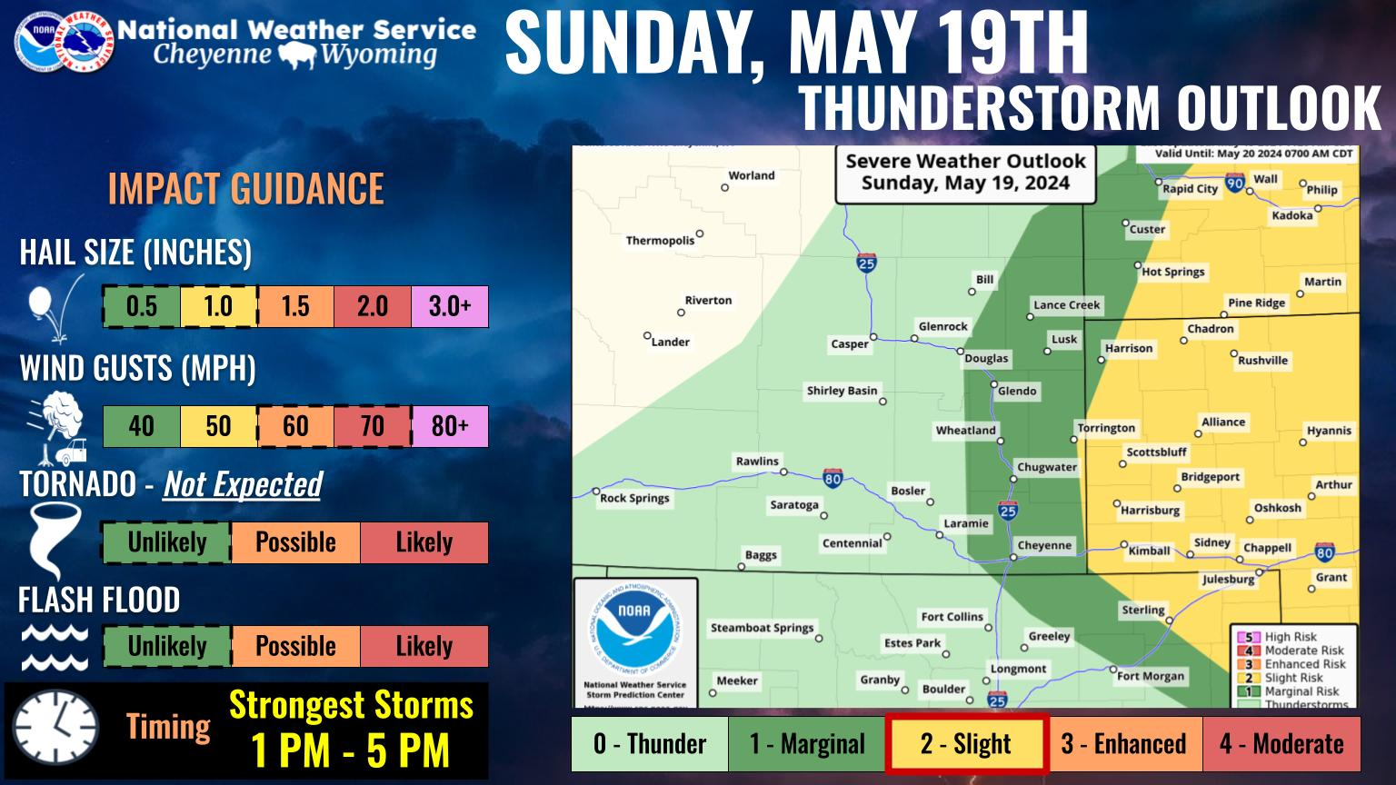
 Mild temperatures will give way to scattered to numerous rain showers developing this afternoon. Some of the eventual thunderstorms that develop could be strong to potentially severe. We have a Marginal Risk for severe weather (1 out of 5) for areas east of the Interstate corridor. The strongest of thunderstorms are anticipated to be from 3-10pm MDT, but they have the potential to linger overnight in the Nebraska Panhandle. Stay tuned to weather updates today as the forecast evolves; the potential for an expansion of the Marginal or Slight Risk for severe weather regions does exist. Please have multiple ways to receive weather warnings. For more information on your local forecast go to: weather.gov/cys


Cheyenne, Laramie Forecast:

Cheyenne Forecast:

Today
Showers and thunderstorms likely, mainly after 3pm. Some of the storms could produce small hail and gusty winds. Mostly sunny, with a high near 71. Southwest wind 10 to 15 mph. Chance of precipitation is 60%. New rainfall amounts of less than a tenth of an inch, except higher amounts possible in thunderstorms.
Tonight
Showers and thunderstorms likely, mainly before midnight. Some of the storms could produce small hail and gusty winds. Mostly cloudy, with a low around 44. Breezy, with a northwest wind 15 to 20 mph, with gusts as high as 30 mph. Chance of precipitation is 60%. New rainfall amounts between a tenth and quarter of an inch, except higher amounts possible in thunderstorms.
Friday
A chance of showers and thunderstorms, then showers likely and possibly a thunderstorm after noon. Mostly cloudy, with a high near 58. Breezy, with a northwest wind 15 to 25 mph, with gusts as high as 35 mph. Chance of precipitation is 70%.
Friday Night
Showers likely and possibly a thunderstorm. Mostly cloudy, with a low around 36. North wind 5 to 15 mph. Chance of precipitation is 70%.
Saturday
Showers likely and possibly a thunderstorm. Cloudy, with a high near 43. North northeast wind 10 to 15 mph. Chance of precipitation is 70%.
Saturday Night
Rain showers likely before 4am, then a chance of rain and snow showers. Some thunder is also possible. Mostly cloudy, with a low around 34. Breezy. Chance of precipitation is 70%.
Sunday
A chance of rain and snow showers before 7am, then a chance of rain showers. Some thunder is also possible. Mostly cloudy, with a high near 54. Breezy. Chance of precipitation is 50%.
Sunday Night
A slight chance of showers before midnight. Partly cloudy, with a low around 35. Breezy.
Monday
Sunny, with a high near 63. Breezy.
Monday Night
Mostly clear, with a low around 38. Breezy.
Tuesday
Mostly sunny, with a high near 68.
Tuesday Night
Mostly clear, with a low around 40.
Wednesday
Mostly sunny, with a high near 67.
Laramie Forecast
Today
Showers and thunderstorms likely, mainly after 3pm. Increasing clouds, with a high near 64. South southwest wind 10 to 15 mph becoming west northwest in the afternoon. Chance of precipitation is 60%. New rainfall amounts of less than a tenth of an inch, except higher amounts possible in thunderstorms.
Tonight
Showers and thunderstorms likely, mainly before 9pm. Mostly cloudy, with a low around 38. West northwest wind 10 to 15 mph. Chance of precipitation is 60%. New rainfall amounts of less than a tenth of an inch, except higher amounts possible in thunderstorms.
Friday
A chance of showers and thunderstorms, then showers likely and possibly a thunderstorm after noon. Mostly cloudy, with a high near 53. Breezy, with a north northwest wind 15 to 20 mph, with gusts as high as 30 mph. Chance of precipitation is 70%.
Friday Night
Rain showers likely before midnight, then rain and snow showers. Some thunder is also possible. Low around 33. North northeast wind 5 to 15 mph. Chance of precipitation is 80%. Little or no snow accumulation expected.
Saturday
Snow showers likely before noon, then rain showers likely. Some thunder is also possible. Cloudy, with a high near 40. Northeast wind 5 to 15 mph. Chance of precipitation is 70%.
Saturday Night
Rain and snow showers likely before 1am, then a chance of snow showers. Some thunder is also possible. Mostly cloudy, with a low around 31. Chance of precipitation is 70%.
Sunday
A chance of snow showers before 8am, then a chance of rain and snow showers between 8am and noon, then a chance of rain showers after noon. Some thunder is also possible. Partly sunny, with a high near 50. Breezy. Chance of precipitation is 50%.
Sunday Night
A slight chance of showers before midnight. Partly cloudy, with a low around 31. Blustery.
Monday
Mostly sunny, with a high near 57. Breezy.
Monday Night
Mostly clear, with a low around 34. Breezy.
Tuesday
Sunny, with a high near 65. Breezy.
Tuesday Night
Mostly clear, with a low around 36. Breezy.
Wednesday
Sunny, with a high near 64.

Best Playground in Cheyenne, According to Locals

Gallery Credit: Joy Greenwald