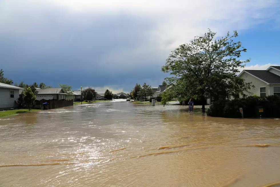
The Cheyenne Office of the National Weather Service says a large swath of southeast Wyoming, including the cities of Cheyenne and Laramie, is facing a flood watch on Monday.

The watch will take effect at noon today [June 12] Heavy rain and small hail are also possible.

The agency posted the following on it's website:

A Flood Watch is in effect this afternoon and evening for all of Laramie County including Cheyenne, and for much of central and southern Albany County including Laramie, as well as southwest Platte County. Flash flooding caused by excessive rainfall is possible from slow moving thunderstorms and thunderstorms moving over the same area. Rainfall totals of 1 to 3 inches are possible with isolated higher amounts. Please monitor later forecasts and be prepared to take action should Flash Flood Warnings be issued.

Showers and thunderstorms will develop across the area once again Monday afternoon and evening with the potential for heavy rainfall and small hail. There is a slight risk of Excessive Rainfall (NOT severe thunderstorms) that could lead to localized flooding in low-lying areas. Use caution if traveling and remember when approaching flooded roads to turn around, don’t drown.

Here is the forecast for Cheyenne:

Today

Showers and thunderstorms. Some of the storms could produce heavy rain. Patchy fog before 9am. High near 59. Southeast wind around 15 mph. Chance of precipitation is 90%. New rainfall amounts between a half and three quarters of an inch possible.
Tonight
Showers and thunderstorms, mainly before midnight. Some of the storms could produce heavy rain. Patchy fog after 2am. Low around 47. South southeast wind 5 to 15 mph becoming northwest after midnight. Chance of precipitation is 80%. New rainfall amounts between a tenth and quarter of an inch, except higher amounts possible in thunderstorms.
Tuesday
A chance of showers and thunderstorms, then showers likely and possibly a thunderstorm after noon. Widespread dense fog, mainly before 8am. Otherwise, mostly cloudy, with a high near 64. North northwest wind 5 to 10 mph becoming southeast in the afternoon. Chance of precipitation is 70%.
Tuesday Night
A 20 percent chance of showers and thunderstorms before midnight. Mostly clear, with a low around 46. Southeast wind 5 to 10 mph becoming west after midnight.
Wednesday
A 40 percent chance of showers and thunderstorms after noon. Mostly sunny, with a high near 73. West southwest wind 10 to 15 mph.
Wednesday Night
A 30 percent chance of showers and thunderstorms before midnight. Mostly cloudy, with a low around 51.
Thursday
Showers likely and possibly a thunderstorm after noon. Mostly sunny, with a high near 72. Chance of precipitation is 60%.
Thursday Night
A chance of showers and thunderstorms before midnight. Mostly cloudy, with a low around 48.
Friday
A chance of showers and thunderstorms after noon. Mostly sunny, with a high near 71.
Friday Night
Partly cloudy, with a low around 49.
Saturday
Sunny, with a high near 78.
Saturday Night
Partly cloudy, with a low around 52.
Sunday
A chance of showers and thunderstorms. Mostly sunny, with a high near 80.

Here is the Laramie forecast:

Today
Showers and thunderstorms. Some of the storms could produce heavy rain. High near 54. South southeast wind 10 to 15 mph becoming southwest in the afternoon. Chance of precipitation is 90%. New rainfall amounts between a half and three quarters of an inch possible.
Tonight
Showers and thunderstorms likely, mainly before midnight. Some of the storms could produce heavy rain. Mostly cloudy, with a low around 43. West southwest wind 5 to 10 mph. Chance of precipitation is 70%. New rainfall amounts between a tenth and quarter of an inch, except higher amounts possible in thunderstorms.
Tuesday
A chance of showers before 9am, then a chance of showers and thunderstorms between 9am and noon, then showers likely and possibly a thunderstorm after noon. Mostly cloudy, with a high near 55. West wind 5 to 10 mph becoming east in the afternoon. Chance of precipitation is 70%.
Tuesday Night
A 20 percent chance of showers and thunderstorms before midnight. Partly cloudy, with a low around 43. Southeast wind 5 to 10 mph becoming west southwest after midnight.
Wednesday
A 50 percent chance of showers and thunderstorms after noon. Mostly sunny, with a high near 64. West wind 10 to 15 mph.
Wednesday Night
A 30 percent chance of showers and thunderstorms before midnight. Mostly cloudy, with a low around 46. Breezy.
Thursday
A slight chance of showers, then showers likely and possibly a thunderstorm after noon. Partly sunny, with a high near 62. Chance of precipitation is 70%.
Thursday Night
A chance of showers and thunderstorms before midnight. Mostly cloudy, with a low around 43.
Friday
A slight chance of showers, then a chance of showers and thunderstorms after noon. Mostly sunny, with a high near 63.
Friday Night
A slight chance of showers and thunderstorms before midnight. Partly cloudy, with a low around 45.
Saturday
A slight chance of showers and thunderstorms. Mostly sunny, with a high near 68.
Saturday Night
Mostly clear, with a low around 48.
Sunday
A chance of showers and thunderstorms. Mostly sunny, with a high near 70.

College National Finals Rodeo-Sunday

College National Finals Rodeo-Sunday