While Cheyenne and Laramie aren't expecting heavy snow with a winter storm that is expected to pass through the region, they are expected to see strong winds, blowing snow, and wind chills that could hit the sub-zero range.

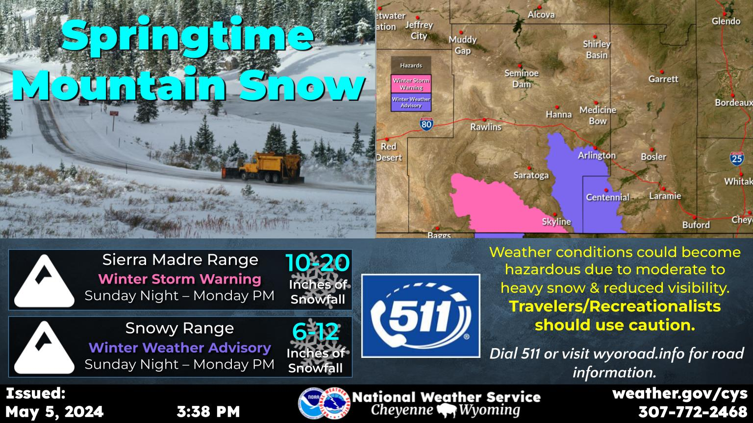
And higher elevations in southeast Wyoming could get as much as 18 inches of snow.

That's according to the Cheyenne Office of the National Weather Service. The agency posted the following on its website:

Winter Storm Watches for the Snowy and Sierra Madre ranges have been upgraded to Winter Storm Warnings, in addition to a Winter Storm Watch has been issued for the Arlington area. Travel may become difficult with snow covered roads and blowing snow with strong winds could significantly reduce visibility at times. Check weather.gov/cys for the latest local forecast.

Cheyenne and Laramie Will See Some Impacts As Well

Cheyenne Weather Forecast:

Today
Sunny, with a high near 56. Windy, with a west wind 30 to 40 mph, with gusts as high as 55 mph.
Tonight
A chance of rain and snow between 11pm and midnight, then a chance of snow after midnight. Increasing clouds, with a low around 21. Breezy, with a west southwest wind 15 to 20 mph, with gusts as high as 30 mph. Chance of precipitation is 50%.
Tuesday
Snow likely, mainly before 11am. Patchy blowing snow between 9am and 11am. Partly sunny, with a high near 31. Blustery, with a northwest wind 15 to 25 mph, with gusts as high as 35 mph. Chance of precipitation is 70%. New snow accumulation of less than one inch possible.
Tuesday Night
A 20 percent chance of snow before 11pm. Mostly clear, with a low around 10. Wind chill values between -5 and 5. Blustery, with a west northwest wind around 20 mph, with gusts as high as 30 mph.
Wednesday
Sunny, with a high near 40. Breezy, with a southwest wind 15 to 25 mph, with gusts as high as 35 mph.
Wednesday Night
Mostly clear, with a low around 24. Breezy.
Thursday
Mostly sunny, with a high near 54. Breezy.
Thursday Night
Mostly clear, with a low around 30.
Friday
Mostly sunny, with a high near 57. Breezy.
Friday Night
Partly cloudy, with a low around 31.
Saturday
Mostly sunny, with a high near 59. Breezy.
Saturday Night
A slight chance of rain and snow. Partly cloudy, with a low around 27. Breezy.
Sunday
A chance of snow. Mostly sunny, with a high near 47. Breezy.
Laramie Weather Forecast
Today
Sunny, with a high near 46. Windy, with a west southwest wind 20 to 25 mph increasing to 30 to 35 mph in the morning. Winds could gust as high as 50 mph.
Tonight
Snow, mainly after 11pm. Low around 21. Blustery, with a southwest wind 10 to 20 mph, with gusts as high as 30 mph. Chance of precipitation is 80%. New snow accumulation of around an inch possible.
Tuesday
Snow likely, mainly before 11am. Patchy blowing snow before 11am, then patchy blowing snow after 1pm. Partly sunny, with a high near 28. Blustery, with a west wind 15 to 25 mph, with gusts as high as 35 mph. Chance of precipitation is 70%. New snow accumulation of less than one inch possible.
Tuesday Night
Patchy blowing snow. Mostly cloudy, then gradually becoming clear, with a low around 4. Wind chill values between -5 and -15. Breezy, with a west wind 20 to 25 mph, with gusts as high as 35 mph.
Wednesday
Sunny, with a high near 34. Breezy, with a west southwest wind 15 to 25 mph, with gusts as high as 35 mph.
Wednesday Night
Mostly clear, with a low around 21. Breezy.
Thursday
Sunny, with a high near 47. Breezy.
Thursday Night
Mostly clear, with a low around 30. Breezy.
Friday
Mostly sunny, with a high near 49. Breezy.
Friday Night
Mostly clear, with a low around 31. Breezy.
Saturday
Mostly sunny, with a high near 50. Breezy.
Saturday Night
A slight chance of snow. Partly cloudy, with a low around 24. Breezy.
Sunday
A chance of snow. Partly sunny, with a high near 40. Breezy.

Look How Much Cheyenne Has Changed In 17 Years!

A trip all the way back to 2007. Get your baggy jeans ready.

Gallery Credit: Google Maps